|
|
| Site Summary | ||||||||||||||||||||||||||||||||||
|
||||||||||||||||||||||||||||||||||
Site History The property encompassing site 18CV151 was patented by Woodman Stoakley in 1658, but the site itself was certainly not settled at that time. Chain of title is incomplete because of a fire in the Calvert County courthouse, but diagnostic artifacts dating to the ca. 1760-1830 period suggest that the site’s occupation correlates with a period of ownership by the Somervell family (ca. 1773-1815). The Somervells were a prominent family in Calvert County and they seem to have established themselves as plantation proprietors when they purchased the Stoakley tract. In 1783, John Somervell was listed as an occupant of the property in the Tax Assessment records. He owned two males slaves at the time. By 1800 he had 11 slaves, and by 1810 he had 26. Site 18CV151 probably represents habitation by these enslaved individuals.
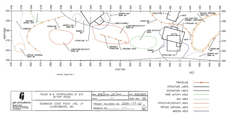
Archaeology Site 18CV151 was first identified in 1981 during a survey of the Patuxent River drainage. At the time, no excavations were undertaken because the site was evident through surface observation of an agricultural field. Further investigations took place in 2005 and 2006 as the site was slated for disturbance by the expansion of the Cove Point LNG Terminal. Phase II testing included 161 shovel tests, 10 excavation units, two mechanical trenches, and some feature excavations. The significance of the site was established, but impact from the project could not be avoided, so Phase III excavations took place in 2006. Plowzone was sampled during the Phase III data recovery with the excavation of 10 5x5' test units. A 48 x 185' excavation block was then mechanically stripped to reveal features. Fifty-eight features were mapped and excavated. Analysis of artifacts, features, and soil chemistry suggest the presence of four structures. Structure 1A was a 12’ x 16’ log house with daub and chinking. Although no foundations were exposed, two sub-floor pits, two drainage ditches, and a possible brick hearth base serve as evidence of the structure’s orientation. Structure 1A was abandoned by ca. 1802, and Structure 1B was built on the same location, but with a different orientation. Structure 1B was a frame or log house on sills with post or pier supports set in the ground. The structure contained one sub-floor pit and a porch, and it was abandoned ca. 1814. Structure 2 is interpreted as a free-standing root cellar of unknown date just north of Structure 1B. Finally, Structure 3 was identified as the earliest dwelling in the project area. Although not fully exposed, it appears to have been a post-in-ground house measuring at least 17’ x 18’. It had a brick chimney base, a dirt floor, and one sub-floor pit. This structure was abandoned ca. 1780. Fence lines, trash middens, hearth ash dumps, and a possible animal pen were identified in the yard around these structures. The interpretation of the site as a slave occupation is based on the nature of the dwellings, the relatively low number of domestic artifacts for the period of occupation, and the faunal analysis, which indicated that meat was butchered off site, and the cuts that made it to the site were primarily those used in soups and stews. Summary by Sara Rivers Cofield References
The Bowens Road II site archaeological collection is owned by the Maryland Historical Trust and curated by the Maryland Archaeological Conservation Laboratory. |
||||||||||||||||||||||||||||||||||

|

|


